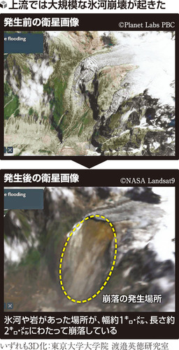
Regarding the large-scale debris flow that occurred on the 26th in the border area between Nepal and China, Hidenori Watanabe, a professor at the University of Tokyo who specializes in satellite image analysis, revealed his analysis results indicating that the collapse of glaciers and rocks over a width of about 1 kilometer and a length of about 2 kilometers was highly likely the cause.
The debris flow reportedly rushed down with tremendous force over an elevation difference of about 4,600 meters and a straight-line distance of more than 70 kilometers.
Professor Watanabe analyzed data from before and after the debris flow, captured by U.S. Earth observation satellites and others, by converting it into 3D.
At a point about 5,000 meters above sea level, he confirmed that soil had been exposed by the large-scale collapse of glaciers and rocks.
Professor Watanabe speculates, 'The collapse of this glacier served as a trigger, and a huge amount of ice and rock flowed down while sweeping up sediment.'
According to the U.S. Geological Survey (USGS), the glacier collapse released energy equivalent to a magnitude (M) 5.2 earthquake.
The debris flow rushed down along the valley and engulfed surrounding villages.
There were also places where sediment climbed about 700 meters up slopes from the riverbank.
Professor Watanabe said, 'This is an unprecedented disaster.'
He said, "It has been said that global warming would cause glaciers to collapse and floods to occur frequently, but perhaps a real example has now appeared."